
Spesifikasi GPS Geodetik/GNSS Hi-Target vRTK
Satellite Signals Tracked Simultaneously
- Channels: 1408/800+ (Optional)
- GPS: L1CA / L1C / L2P(Y) / L2C / L5
- BDS: B1l / B2l / B3l / B1C / B2a / B2b*
- GLONASS: L1/L2/L3
- Galileo: E1 / E5a / E5 / AltBOC / E5b / E6
- SBAS: L1C/A, L5(QZSS, WAAS, MSAS, GAGAN)
- QZSS: L1 / L2 / L5 / L6*
- IRNSS: L5
POSITIONING PERFORMANCE
- High Precision static
- Horizontal : 2.5mm + 0.1ppm RMS
- Vertical: 3.5mm + 0.4ppm RMS
- Static and Fast Static
- Horizontal: 2.5mm + 0.1ppm RMS
- Vertical: 3.5mm + 0.4ppm RMS
- Post Processing Kinematic (PPK / Stop & Go)
- Horizontal: 8mm + 1ppm RMS
- Vertical: 15mm + 1ppm RMS
- Initialization time: Typically 10 min for base and 5 min for rover
- Initialization reliability: Typically > 99.9%
- Code Differential GNSS Positioning
- Horizontal: ±0.25m + 1ppm RMS
- Vertical: ±0.5m + 1 ppm RMS
- SBAS: 0.5m
Real Time Kinematic (RTK)
- Single Baseline
- Horizontal: 8mm+1ppm RMS
- Vertical: 15mm+1ppm RMS
- Network RTK(VRS, FKP, MAC)
- Horizontal: 8mm+0.5ppm RMS
- Vertical: 15mm +0.5ppm RMS
- Initialization Time: Typically 2-10s
- Initialization Reliability: Typically > 99.99%
- Provides RTK measurement even during differential signal interruptions
- Hi-Fix
- Horizontal: RTK+10mm / minute RMS
- Vertical: RTK+20mm / minute RMS
- Time to first Fix
- Cold Start: <45 s
- Hot Start: < 30 s
- Signal re-acquisition: < 2 s
- Image Accuracy
- Stakeout: Typically 2cm
- Image measurement: 2cm~4cm
- Tilt Survey Performance
- Additional horizontal pole-tilt uncertainty typically less than 8mm+0.7mm/°tilt(2.5cm accuracy in the inclination of 60°)
HARDWARE
- Physical
- Dimensions (W x H): 130mm x 79mm
- Wieght: lighter than 0.97kg (2.14lb) within internal battery
- Operation temperature: -40°C~+75°C (-40°F~+167°F)
- Storage temperature: -55°C~+85°C (-67°F~+185°F)
- Temperature Control: Auto-adjust the working power to maintain the temperature
- Humidity: 100% non-condensing
- Water/dustproof: IP68, protected from temporary immersion to depth of 1.0m (3.28ft)
- Shock and vibration: MIL-STD-810G, 514.6
- Anti-salt spray: MIL-STD-810G, 509.4, 96h
- Free fall: MIL-STD-810G, 516.6, designed to survive a 2m(6.56ft) natural fall onto concrete
- Charging
- Charging: using standard smartphone chargers or external power banks (support 5V 2.8A Type-C USB External Charging)
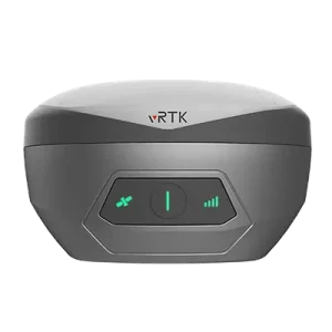
- Control Panel
- Physical Button: 1
- LED Lights: Satellite lights, signal lights, power lights
- Camera
- Pixel: 2MP & 5MP Support real scene stakeout, image measurement, working distance 2~15m
- Internal Battery
- 7.2V, 6900mAh, Built-in lithium-ion Battery.
- RTK rover(UHF/Celullar) for 15 hours.
- Power indicator embedded.
- Quick charge within 3.5 hours.
- I/O Interface
- Bluetooth 4.0/2.1+EDR, 2.4GHz USB Type C interface; SMA interface;
- Nano SIM card slot
- Near Field Communication (NFC)
COMMUNICATION
- Network Communication
- Full band support for cellular mobile network(LTE, WCDMA, EDGE, GPRS, GSM). 2.4GHz Wi-Fi, supports the standard protocol 802.11 b/g/n. Network RTK(in CORS) range is 20-50km.
- Internal UHF Transceiver Radio
- Frequency: 410~470MHz
- Transmitting Power: 0.5W / 1W / 2W adjustable Hi-Target
- Support protocols: HI-TARGET, TRIMTALK450S, TRIMMARK III, SATEL-3AS, TRANSEOT, etc.
- Working Range: Typically 3-5km, optimal 5~8km
- Channels: 116
SYSTEM CONFIGURATION
- System
- Data Storage: Circulating 8GB Internal Storage, Record GNS and RINEX format simultaneously
- Data Formats
- 1Hz positioning output, up to 20Hz. RTCM2.X, RTCM3.X.
- Navigation outputs ASCII: NMEA-0183
Alamat kami :
Komplek Grand Gading Mas No 2GG, Jl Sumber Amal, Kedai Durian, Medan Sumatera Utara


